
What’s New at the Reserve? Spring 2025
The work never stops at the Lake Superior Reserve!
After months of preparation, the Lake Superior Reserve staff hosted their 15th Annual St. Louis River Summit at the beginning of March. More than 300 community members and natural resources professionals attended the event held at the Yellowjacket Union of UW-Superior. Attendees were able to learn about the research, restoration, and community building happening on and around the St. Louis River estuary.
As the warmer months approach, staff eagerly await the field season and the arrival of seasonal staff to help with research and education. See below for more on what the Lake Superior Reserve has been up to, and what is upcoming.
15th Annual St. Louis River Summit
The 15th Annual St. Louis River Summit was attended by more than 300 community members and natural resources professionals throughout the three-day event on March 4-6. The annual event is hosted at the University of Wisconsin-Superior Yellowjacket Union, and the theme for this year’s summit was An Estuary Mosaic: Understanding the Pieces, Appreciating the Whole.
The Summit gathers various individuals, agencies, and organizations for talks, networking sessions, keynote panels, field trips, and discussions of various topics centered around the Lake Superior watershed. In total, 24 oral talks were given. Additionally, 30 posters and 16 art pieces were presented at the Poster and Artwork Session. There were two panels, one on tribal sovereignty and water quality, as well as a discussion on climate resilience. The Summit reminds all of us who work together in this place why we work so hard to protect the estuary.
This event would not be possible without the many generous sponsors of the Summit, as well as UW-Superior for hosting the event. The official 15th Annual St. Louis River Summit proceedings can be found here: 2025 St. Louis River Summit Proceedings
The 16th Annual St. Louis River Summit is planned to be held at UW-Superior’s Yellowjacket Union on March 3-5, 2026. More information will be available leading up to the event.
Photos:
left to right: 1. Lake Superior Reserve staff and registration desk volunteers; 2. “Climate Resilience is Every Day” panel; 3. Nancy Schultz (Water Project Coordinator with Fond du Lac Environmental Program) delivers the keynote presentation on water quality and tribal sovereignty. ; 4. Attendees of the St. Louis River Summit watch oral presentations. (credit: Michael Anderson)


Algal I.D. Training

Photo: a harmful algal bloom on the St. Louis River (credit: Addi Knoll)
Harmful algal blooms (HABs) are emerging as a larger, more frequent threat across the nation due to climate change. HABs occur when algae grows out of control, and the growth of this algae is accelerated by warmer water temperatures and excess amounts of oxygen present in bodies of water. Often, these algal blooms produce toxins that can be harmful to humans, pets, and wildlife.
Blooms were once rare in the St. Louis River estuary and Lake Superior’s nearshore, but have become more frequent in the past decade. To combat this growing threat on Lake Superior and the St. Louis River estuary, Lake Superior Reserve research, monitoring, and coastal training staff have put together an Algal Identification Training. This training will educate local managers and monitors of coastal waterfront spaces how to identify, test, and take action when an algal bloom is observed. It includes the chance for participants to practice using test strips to detect the presence of toxins. The efficacy of toxin test strip technology has been studied by the Reserve’s research program.
Though the training is at full capacity, you can be added to the waitlist by clicking here: Algal ID Training Waitlist. You can also learn more about harmful algal blooms (HABs) from the National Oceanic and Atmospheric Administration (NOAA) on their website: What is a Harmful Algal Bloom?
Lake Superior Estuarium Docent Training

photo: Lake Superior Estuarium building (credit: Lake Superior Reserve)
The Lake Superior Estuarium (estuary + museum) is a crucial part of the Lake Superior Reserve outreach effort. The Estuarium, located on Barker’s Island, is a free exhibit hall with information about and interactive maps of the St. Louis River Estuary and the Lake Superior Reserve. There is also a play area for children, including books to read, drawing and coloring, and a small indoor playground.
The Lake Superior Estuarium would not be possible without our wonderful volunteer docents who help staff and educate visitors on the Estuarium, the St. Louis River estuary, and the work of the Lake Superior National Estuarine Research Reserve. To become a volunteer, Lake Superior Reserve education staff and Friends of the Lake Superior Reserve are holding a Lake Superior Estuarium Docent Training on Tuesday, May 27 and Saturday, May 31 from 10-11:30 am. Interested volunteers only need to attend one of these dates. Docents greet and converse with Estuarium visitors, as well as manage the building during open hours. Education staff and the Friends group encourage any community members who are passionate about the watershed and want to make a difference in the community to volunteer.
More information to sign up for the training is here: Lake Superior Estuarium Docent Training Registration
System-wide Monitoring Program
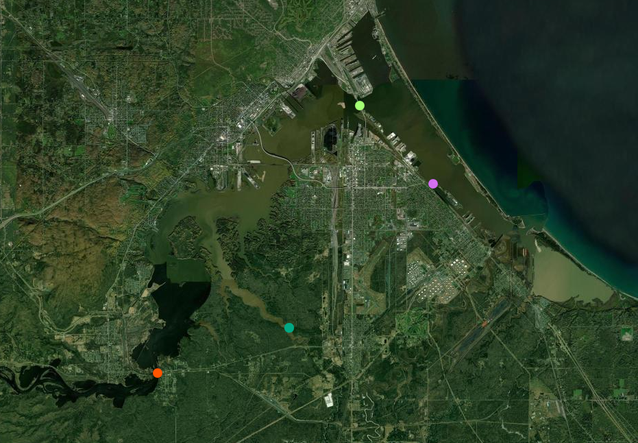
Lake Superior Reserve System-wide Monitoring Program Map; sites include Oliver Bridge, Pokegama Bay, Blatnik Bridge, and Barker’s Island (credit: Lake Superior Reserve)
One of the main projects of the National Estuarine Research Reserve System is collecting water quality data for research and monitoring our coastal ecosystems. The System-wide Monitoring Program (SWMP), which falls under NOAA’s Office of Coastal Management, utilizes various technological methods to measure water quality, weather, and wetland vegetation plots. This data, which is collected yearly, informs us of changes over time. Every reserve in the system is a part of this program, and it is a vital tool to create restoration and protection efforts to combat climate change.
Since the Lake Superior Reserve experiences cold winters and lots of ice, data is only collected when there is open water during the warmer months. The Lake Superior Reserve uses devices called sondes to measure various metrics of water quality, including temperature, pH, and dissolved oxygen. The Reserve also has a weather station in Pokegama Bay (Superior, WI) that collects weather data year-round.
In the past month as the ice has melted from the river, the Lake Superior Reserve began deploying sondes at various sites across the St. Louis River Estuary (see map of SWMP sites in the St. Louis River estuary). These devices will remain on site until the temperatures dip below freezing again in the fall. The Reserve’s monitoring team also collects water samples utilizing a smaller sonde and a horizontal water sampler throughout the year as another method to analyze water quality. To learn more about the NERR System-wide Monitoring Program, visit NOAA Office for Coastal Management website: NOAA Digital Coast
To see live data collected from the monitoring sites of the Lake Superior Reserve, click here:https://lakesuperiornerr.org/
Photos: left to right
1. Lake Superior Reserve staff deploying a sonde under the Blatnik Bridge (credit: Callie Grones) ; 2. Lake Superior Reserve Water Quality Technician, Addi Knoll, with a sonde shortly before its deployment (credit: Callie Grones) ; 3. SWMP Weather Station in Pokegama Bay (credit: Lake Superior Reserve) ; 4. AmeriCorps member Callie Grones collects a water sample under the Oliver Bridge (credit: Addi Knoll)


*Coming Soon* St. Louis River Habitat Map

Photo: St. Louis River Habitat Map team presents a poster of the first draft of the habitat map at the St. Louis River Summit. (credit: Michael Anderson)
The Lake Superior Reserve stewardship team has been working on a high resolution habitat map of the St. Louis River Estuary, which is set to be finalized this spring. As one of many local, state, tribal, and federal entities that do restoration, conservation, and stewardship work in this place, this new habitat map will help inform new projects and highlight changes over time.
A link to this new St. Louis River Estuary Habitat Map will be available in our summer newsletter.
2025 River Walks series
The River Walks series returns this spring starting in June through October. The series gives participants a chance to get outside and learn about local land and water projects while exploring various places along the St. Louis River estuary.
More information will be available for the River Walks series on the Lake Superior Reserve website:https://lakesuperiornerr.org/coastal-training/river-walks/
Article by Callie Grones, edits by Karina Heim
Cover photo: Lake Superior Reserve staff and researchers gather in front of a puppet lantern at the 15th Annual St. Louis River Summit (credit: Luciana Ranelli)